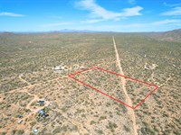
Corner Lot with Mountain Views
Pfotenhauer Rd : Fort Garland, CO 81133
Costilla County, Colorado
Farm Description
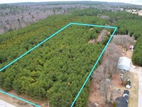
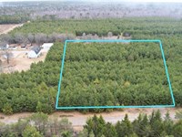
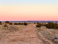
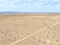
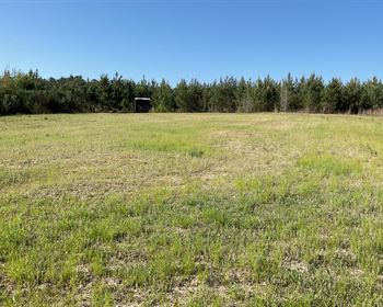
Camp, park your RV, or build your getaway on this 5.00 acre property on Pfotenhauer Rd in Fort Garland, CO. The land has a private mountain foothill feel with desert vegetation and road access along two sides of the parcel. The area is rural, quiet, and mostly undeveloped with very few nearby homes.
Sangre de Cristo Ranches is also well known for its outstanding hunting and wildlife opportunities. Located primarily within Colorado Game Management Unit 83, the area is home to abundant populations of elk, mule deer, antelope, black bear, turkey, and small game. The region borders vast stretches of public lands and mountain terrain, making it a popular destination for hunters, outdoor enthusiasts, and nature lovers alike.
Many properties in the ranches offer direct access to thousands of acres of nearby recreational land, while the subdivision itself includes designated greenbelt areas reserved for owners to enjoy hiking, hunting, and exploring. Elk are especially common throughout the foothills and higher elevations, with the San Luis Valley known for supporting one of Colorado's largest elk herds.
Beyond hunting season, the area is rich in year-round wildlife viewing opportunities, where it's common to spot deer grazing, hawks soaring overhead, and elk moving through the valleys at sunrise and sunset. Whether you're looking for a recreational getaway, hunting basecamp, or peaceful mountain retreat, Sangre de Cristo Ranches offers an authentic Colorado outdoor lifestyle.
5.00 Acres in Fort Garland, Colorado
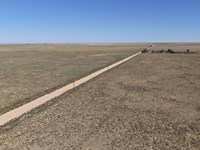
Road frontage on two sides of the parcel
Estate Residential zoning
Mobile homes allowed (1976 or newer)
Camping and RV use allowed
Sangre de Cristo Ranches Owners Community (Scro)
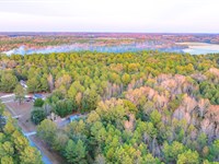
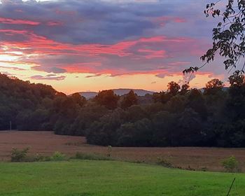
Valley & Mountain views
Fiber optic cable nearby
Some cellular signal available
Solar or generator-friendly area
Approximately 37 miles to Alamosa for major shopping and services
Property Details:
Land & Terrain
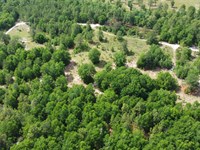
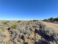
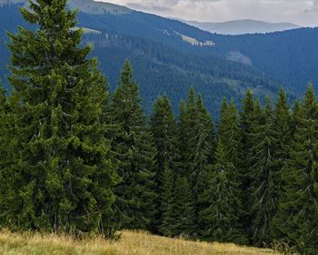
Terrain is sloped uphill to the South. There is a low drainage area sloping down through the middle towards the northwest. With native grasses, sagebrush, and a mix of juniper and pinon-style tree coverage.
Road Access
Access to the property is good, with road frontage along two edges of the parcel and well-maintained roads leading into the area. You have 2 road access giving you easy travel all the time.
Utilities
Within teritory, no available power lines nearby. Solar or generator would be the best option The only noted utility is fiber optic cable located across the street at the northwest intersection. Some cellular signal is also available in the area.
Views & Surroundings
You will have a valley views to the west and mountain views to the north, along with surrounding forested hills and nearby ridgelines. There is one neighboring home to the east on higher ground above the parcel, with no other nearby neighbors.
Zoning - Estate Residential
Minimum dwelling size is 600 sq ft, and all homes must contain a kitchen and bathroom. Applications must include a site plan and structure drawings showing dimensions and floor plans.
Mobile homes, camping, and RV use are allowed subject to County regulations.
Camping in an RV or shelter for more than 14 days within any consecutive three-month period requires a Long-Term Camping Permit. Long-Term RV permits require an approved wastewater system, permitted well or cistern, proof of ownership, and compliance with County regulations and subdivision covenants. Permits are valid for 60 days and may not exceed 180 days per RV, person, or parcel within any 12-month period. Only one RV is allowed per parcel, RVs may not be used as permanent dwellings, and no structures may be attached to RVs. RV living and hunting are prohibited.
Manufactured homes must be 1976 or newer and require all State and County permits and inspections. Garages and storage sheds may only store building materials and tools during construction and may not be used as temporary dwellings.
Nearby Essentials
Fort Garland is the closest town for gas, food, and small-town services. Fort Market Grocery is located nearby, while Alamosa is about 37 miles away for larger shopping, groceries, restaurants, Walmart, Safeway, City Market, Home Depot, and other major services.
Nearest Shopping Area
Alamosa is the nearest main shopping hub and includes Valley Plaza Shopping Center, local shops, restaurants, galleries, antiques, and additional retail services.
Nearby Recreation
Recreation nearby includes Great Sand Dunes National Park, Zapata Falls, Smith Reservoir State Wildlife Area, San Luis State Wildlife Area, Rio Grande National Forest, Sangre de Cristo Wilderness, Fort Garland Museum, scenic mountain drives, hiking, fishing, wildlife viewing, and outdoor exploration.
Part of the Sangre de Cristo Ranches Owners Community (Scro). POA dues are optional and currently $25 per year. Covenants and restrictions exist within the subdivision; however, according to the Scro website, the POA does not actively enforce them and encourages buyers to review Costilla County zoning regulations and subdivision covenants independently.
Nearby Towns & Cities:
Fort Garland, CO (17mins, 12 miles)
San Luis, CO (19mins, 14 miles)
Blanca, CO (22mins, 17 miles)
Alamosa, CO (44mins, 37 miles)
Denver, CO (3hrs 37mins, 219 miles)
Colorado Springs (2hrs 28mins, 151 miles)
Pricing:
Discount Cash Price: $13,999 + non refundable $399 document fee
Owner Financing Price: $14,999 , $4,499 down ($399 doc fee plus $4,100 equity), $186/Mo minimum payment with NO prepayment penalties
We are a small family business and can be flexible. We're happy to fit any budget that meets our minimums. Our owner, Dave Denniston, enjoys making land ownership available to families like yours who want to make memories for years to come. We can owner-finance with a land contract. We can transfer with a warranty deed and guarantee a clean title.
Farm Maps & Attachments
Directions to Farm
NW: 37.3278, -105.3587 (Road)
NE: 37.3281, -105.3568 (Road)
SW: 37.3268, -105.3586 (Road)
Se: 37.327, -105.3566
More Farm Details
More Farms from Reggie Wright
 7.7 AC : $215K
- 5.9 AC : $165K
- 25.5 AC : $158K
- 5.8 AC : $63.1K
- 11.6 AC : $299K
- 10 AC : $259K
- 36.6 AC : $20K
- 40 AC : $36K
- 5.2 AC : $6.6K
- New5.2 AC : $50K
- 5 AC : $60K
- 10 AC : $17K