Sangre Cristo, 5.32 Acres, $258 Dn
Bateman Rd : Fort Garland, CO 81133
Costilla County, Colorado
Farm Description
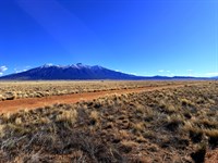
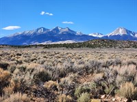
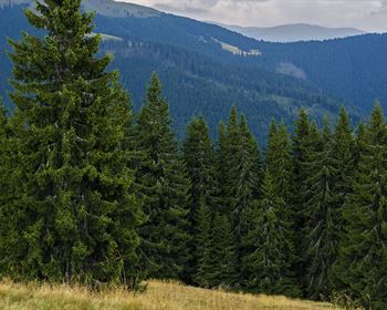
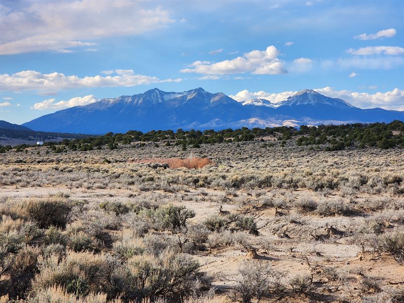
While Phoenix hits 115 degrees in July, this parcel sits at 8,281 to 8,310 feet above sea level in the Sangre de Cristo Ranches of Costilla County, Colorado. The afternoon high here is 72 degrees. The night drops to the high 40s. The air is thin and dry and there is no air conditioning in any cabin in this subdivision - because no one has ever needed it. This is what climate-driven buyers from Arizona, Texas, and Southern California are actively searching for, and the Sangre de Cristo Ranches is delivering exactly what they cannot find at home: genuine high-altitude Colorado land at an entry price that still makes sense.
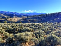
Welcome to Unit E, Block 74, Lot 960 of the Sangre de Cristo Ranches - 5.32 acres of flat, lightly shrubbed rectangle on Bateman Road, at the highest elevation of any property in our current Colorado inventory. At 8,281 to 8,310 feet, you are above the summer heat line that increasingly makes lower-elevation Colorado properties feel like the places buyers are trying to leave. Annual property taxes are $171.20. No mandatory HOA dues. Estate Residential zoning with no time limit to build. Owner financing starts at $258 down - no credit check, no bank required.
Great Sand Dunes National Park is 32 minutes south. Zapata Falls - a 30-foot cascade through a narrow rock canyon, one of the San Luis Valley's finest hidden gems - is 36 minutes away. Fort Garland is 13 minutes north for gas, groceries, and the Fort Garland Museum. Alamosa and its full suite of urban services - hospital, Walmart, Home Depot, regional airport - is under an hour west. The Sangre de Cristo Wilderness begins 30 minutes to the east. GMU 83 elk country is in every direction.
At 8,300 feet, you are not visiting the Colorado that brochures sell. You are living in it.
The Climate Refugee's Case For This Land
The calculus is changing for millions of Americans. Coastal wildfires. Record heat in Arizona, Nevada, and Texas. Flooding along both coasts. Water scarcity in the Southwest. The question is no longer whether to leave - for many households, it is where to go and how to afford it.
The answer for a growing number of them is the San Luis Valley of southern Colorado. Not the ski-resort Colorado of Aspen and Vail - that is already priced out. The working, authentic, high-altitude Colorado that still has land available at prices that allow a genuine fresh start.
Eight thousand three hundred feet in the southern Sangre de Cristo Ranches delivers exactly what the climate calculus demands:
Cooling: Mid-70s in July while Phoenix and Las Vegas are genuinely dangerous outdoors. The temperature difference between this elevation and the Phoenix metro is typically 40 to 50 degrees on the hottest summer days. Forced air conditioning is not a feature of any structure in this community because it is not necessary.
Water: A domestic well in the 150 to 350-Foot range delivers water independence from an aquifer that has served this valley for centuries. No municipal water bill. No drought-driven water restrictions. Your water supply is as secure as the ground under your feet.
Energy independence: Off-grid solar at 8,300 feet in Colorado's sunniest county delivers power without a utility bill, without a utility company's supply interruptions, and without the grid fragility that makes extreme weather events catastrophic in lower-elevation, denser communities.
Internet connectivity: Starlink delivers genuine broadband performance at this elevation without any physical infrastructure. Remote workers, retired professionals staying connected to family, and anyone who needs digital capability without urban density can have both from this parcel.
Hospital proximity: San Luis Valley Health in Alamosa is under one hour - within the threshold most families require for emergency medical access. This is not a remote, inaccessible mountain position. It is a high-altitude rural parcel with a clear path to essential services.
This is the combination that climate-motivated buyers from the coasts and the Sun Belt are specifically searching for. The San Luis Valley is increasingly on that list. This parcel is available now, at today's pricing, before that recognition becomes fully reflected in asking prices.
Property Highlights At A Glance
Parcel: Unit E, Block 74, Lot 960 - Sangre de Cristo Ranches
Apn: 70216040
Legal Description: S.D.C.R. Unit E Blk 74 Lot 960 Cont 5.32 Ac
Address: Bateman Rd, Fort Garland, CO 81133
County: Costilla County, Colorado
GPS Center: 37.358500, -105.360806
Gps Corners: Not provided in DD report - obtain from Costilla County GIS before publishing
Parcel Size: 5.32 acres
Shape: Rectangle
Slope: 3.2% average (flat/level)
Elevation: 8,280.5 ft - 8,310.1 ft above sea level - highest elevation in current inventory
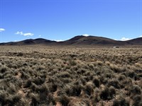
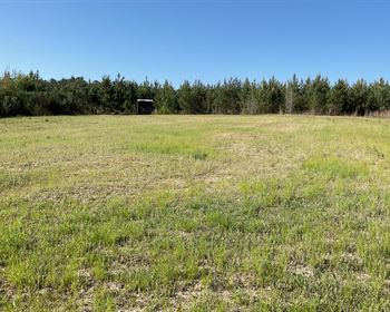
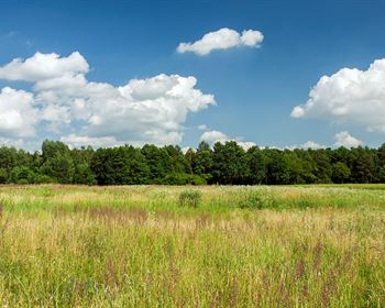
Terrain: Flat, lightly shrubbed rural terrain
Flood Zone: Zone X - outside mapped floodplain
Creek/Wetlands: Minor creek along western property boundary - buyers verify setback requirements with Costilla County planning prior to development
Road Access: Bateman Rd - dirt, county-maintained, legal access confirmed
Zoning: ER - Estate Residential, Costilla County
Single-Family Home: Yes - 600 sq ft minimum
Manufactured Home: Yes - 1979 or newer, Hud-Certified
Modular Home: Yes
Mobile Home: Yes - 1979 or newer, county-compliant
Tiny Home: No - 600 sq ft minimum applies
Time Limit to Build: 3 years from permit issuance
Camping: 14 days per year without permit; longer with construction permit and installed septic
RV: 14 days per year without permit; longer with permit and septic
Full-Time RV: Not permitted without permanent dwelling
Solar: Permitted
Wind Generator: Permitted - small residential
Propane: Permitted - portable or buried
Short-Term Rentals: Yes
HOA: Voluntary Sdcr Community Association - no mandatory dues; optional $25/Year
Annual Taxes: $171.20 (2025) - current, no back taxes, no liens
Fort Garland, CO: 13 min / 9.1 miles
Blanca, CO: 17 min / 13.4 miles
San Luis, CO: 17 min / 15.0 miles
Alamosa, CO: approx. 44 min
Great Sand Dunes National Park: 32 min / 31.0 miles
Zapata Falls: 36 min / 29.2 miles
Pueblo: 1 hr 52 min / 108 miles
Colorado Springs: 2 hr 16 min / 146 miles
Cash Sale Price: $14,999
Owner Financing: From $258 down - no credit check, no bank required
Location And Setting
The Sangre de Cristo Ranches - Established Colorado Mountain Land Community: The Sangre de Cristo Ranches is one of the most established and well-known rural land communities in the San Luis Valley, spanning tens of thousands of acres at the base of the Sangre de Cristo range. County-maintained roads thread through the entire subdivision. Estate Residential zoning protects property values while preserving individual landowner freedom. The voluntary Sdcr Community Association provides community resources without imposing mandatory fees or oversight. This is a known, credible Colorado land address - not a speculative frontier parcel.
Fort Garland - 13 Minutes North: Gas (Conoco 7 min / 4.7 miles), a post office, diners, and the Fort Garland Museum and Cultural Center - the restored 1858 military outpost where Kit Carson served as commanding officer. The practical day-to-day anchor for the northern San Luis Valley.
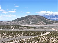
Blanca and San Luis - 17 Minutes: Both the community of Blanca (at the foot of Blanca Peak, Colorado's fourth-highest fourteener) and the historic town of San Luis (Colorado's oldest incorporated municipality, established 1851) are equidistant at approximately 17 minutes. San Luis offers cultural depth - the Stations of the Cross Shrine, authentic local cuisine, and 400 years of Hispanic heritage - that is entirely distinct from resort-town Colorado.
Alamosa - Under 1 Hour: San Luis Valley Health hospital, Walmart Supercenter, Home Depot, Adams State University, and Alamosa Regional Airport with connections to Denver. Full urban services within a one-hour drive.
Pueblo - 1 Hour 52 Minutes: The closest major city, substantially closer than Denver or Colorado Springs. For buyers relocating from the Front Range, Pueblo provides a familiar urban connection that Fort Garland cannot.
Road Access - Bateman Road: County-maintained dirt road with confirmed legal access year-round. No private road dependencies or easement complications.
Zoning And Permitted Uses
Estate Residential (Er) - Costilla County: No mandatory HOA. No architectural review committee. No time pressure imposed by a homeowners association. Your land use decisions are governed by Costilla County zoning - designed to support landowner rights, not restrict them.
Single-Family Home: Build a site-built home of 600 square feet or larger. No maximum size restriction.
Manufactured Home: Permitted - 1979 or newer, Hud-Certified. For buyers who want to be on their land quickly and affordably, a quality manufactured home is one of the most practical paths to permanent high-altitude Colorado occupancy.
Modular Home: Permitted. Factory-built quality with full design flexibility.
Mobile Home: Permitted - 1979 or newer, county-compliant.
Time Limit: Three years from permit issuance. Plan your build, phase the financing, construct when ready - the three-year window gives you the runway to do it right.
Camping and RV: Permitted for 14 days per year without a permit. Extended stays available with a construction permit and installed septic system - used widely throughout the Sangre de Cristo Ranches by buyers building in phases.
Solar and Wind: Both permitted. At 8,300 feet with approximately 340 days of sunshine annually, off-grid solar at this elevation is genuinely exceptional - one of the highest solar irradiance locations in the United States.
Short-Term Vacation Rentals: Permitted per county. Great Sand Dunes proximity and I-25 corridor access from Pueblo create a consistent recreational traveler demand for authentic Colorado high-country accommodation.
Voluntary HOA Only: The Sdcr Community Association is entirely optional. No mandatory fees. No enforcement authority over your property choices.
Recreational Opportunities
Great Sand Dunes National Park - 32 Minutes / 31.0 Miles: North America's tallest sand dunes - some rising over 750 feet - against the Sangre de Cristo Mountains. Sand sledding, sandboarding, wading in seasonal Medano Creek, backcountry hiking, International Dark Sky Park designation, and one of the most visually extraordinary landscapes on the continent. Great Sand Dunes draws 600,000-Plus visitors annually and continues to grow its international recognition. At 32 minutes, this parcel has one of the closest positions to the park available in the Sangre de Cristo Ranches.
Zapata Falls - 36 Minutes / 29.2 Miles: One of the San Luis Valley's finest hidden gems. The approach trail winds into a narrow canyon where a 30-foot waterfall pours through polished volcanic rock - dramatic, intimate, and entirely off the resort-Colorado tourist circuit. The access road to the Zapata Falls trailhead also delivers sweeping San Luis Valley views that make the drive worthwhile regardless of the destination.
Rio Grande River - Gold Medal Trout, 30-40 Minutes: Gold Medal trout water designations on certain reaches of the Rio Grande. Brown trout exceeding 20 inches in the deeper pools and undercut banks. Public BLM walk-in access points. Angling pressure noticeably lighter than comparable Front Range rivers.
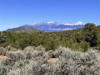
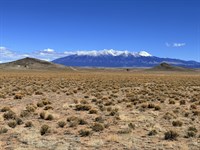
Blanca Peak - Colorado's Fourth-Highest Fourteener, 17 Minutes: The 14,345-Foot summit of Mount Blanca is 17 minutes from this parcel - close enough to see the summit in detail from the property on clear days. Summit routes via Lake Como Road are accessible to fit hikers and technical climbers. Blanca is one of the Navajo Nation's four sacred peaks and carries a cultural and physical presence that defines the entire northern valley skyline.
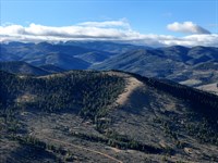
Sangre de Cristo Wilderness - 30 Minutes: 220,000 acres of pristine backcountry. Over 100 miles of maintained trails. Alpine lakes, wilderness ridgelines, and genuine solitude at a scale that most western wilderness areas can no longer provide.
GMU 83 Elk Hunting: This parcel sits within Game Management Unit 83 - home to the Trinchera elk herd of approximately 7,000 animals. Over-the-counter bull elk licenses available for the second and third rifle seasons without a draw. Mule deer, pronghorn, and upland birds complete the hunting portfolio.
Rio Grande National Forest - 45 Minutes: 1.86 million acres surrounding the San Luis Valley. Unlimited dispersed camping, hundreds of miles of hiking and ATV routes, fishing access to upper river tributaries.
Wolf Creek Ski Area - 2.5 Hours: Colorado's snowiest resort. 430 inches of annual snowfall. Legendary powder skiing at prices that have not caught up to the resort's quality.
Dark Sky Stargazing - Every Night: Bortle Class 2-3 from 5.32 open acres at 8,300 feet. The San Luis Valley's position east of the Cascades and west of the Continental Divide creates near-perfect conditions for dark sky astronomy virtually every clear night. At this elevation, the star density is not something that photographs can fully convey.
Wildlife And Natural Environment
At 8,300 Feet - A Complete High-Country Ecosystem: The elevation of this parcel places it above the piñon-juniper zone and into the lower ponderosa-sage transition - a habitat range that supports a wider diversity of wildlife species than lower-elevation San Luis Valley parcels. At 8,300 feet, you are in genuine high-country Colorado, with the ecosystem that comes with it.
Big Game: Elk from GMU 83's Trinchera herd move through the southern Sangre de Cristo Ranches seasonally. Mule deer are year-round residents of the brushy transition terrain, visible from the property at dawn and dusk. Pronghorn inhabit the open valley floor east of the subdivision.
Creek Corridor: The minor creek along the western property boundary creates a micro-riparian habitat that draws deer and elk for water, concentrates migratory birds, and adds ecological diversity to an otherwise open-shrub landscape. The creek is a natural amenity - it provides wildlife viewing from the property that flat, featureless parcels without any water feature cannot offer.
Pacific Flyway - Raptors and Cranes: Golden eagles, red-tailed hawks, and Swainson's hawks patrol the open terrain at this elevation year-round. Sandhill crane migration peaks in March and October - the valley's most iconic wildlife spectacle. Over 200 species documented in the San Luis Valley annually.
Predators: Black bear and mountain lion maintain territories throughout the southern Sangre de Cristo Ranches at this elevation. Their presence is evidence of an intact ecosystem, not a liability.
Utilities And Off-Grid Living
Power - Off-Grid Solar: No visible power lines in the area. Grid extension is not a realistic near-term option for most buyers - off-grid solar is the correct and economically superior path here. At 8,300 feet in Costilla County, the solar resource is exceptional: approximately 340 sunshine days per year, thin mountain air that increases panel efficiency, and cool temperatures that prevent the overheating that reduces output at lower, hotter elevations. A 5 to 10 kW solar array with lithium battery storage reliably powers a well-equipped cabin, manufactured home, or full-size primary residence through all four seasons without a utility bill. Small residential wind generators are permitted for hybrid production during overnight and storm periods.
Water - Well Drilling: No water source on site. Well drilling is standard throughout the Sangre de Cristo Ranches. Area depths run 150 to 350 feet. Complete installation at area depths - pump, pressure tank, electrical - approximately $10,000 to $15,000. Your water supply: independent, reliable, and permanently yours. Water hauling to a cistern provides an interim solution while permitting is underway.
Sewer - Septic System: Required for permanent occupancy. Costilla County manages permits and evaluation. Standard leach field designs throughout the subdivision. Budget $5,000 to $8,000. Creek-adjacent placement should be verified with Costilla County for riparian setback compliance before finalizing septic design.
Propane - Heating and Cooking: No natural gas available. Portable or buried propane tanks are both permitted. At 8,300 feet, a well-insulated structure with propane heating and passive solar design delivers comfortable year-round occupancy.
Internet - Starlink: Genuine broadband performance throughout Costilla County. Unobstructed sky at 8,300 feet - the best possible Starlink operating conditions. For climate refugees who are relocating from cities while maintaining professional careers or client relationships, Starlink closes the connectivity gap that once made rural Colorado impractical for working adults.
Waste: Private hauler or transfer station. Standard for rural Costilla County.
Climate - The Reason 8,300 Feet Matters
The Numbers: While Phoenix averages 110+ degrees on its hottest summer days, this parcel sits at 8,300 feet where afternoon highs in July and August typically reach 72 to 76 degrees Fahrenheit, with nights cooling to the upper 40s and low 50s. The lapse rate of approximately 3.5 degrees per 1,000 feet of elevation means that every 1,000 feet you rise in the Rocky Mountains costs the summer heat roughly 3.5 degrees. At 8,300 feet, you are not splitting the difference between Phoenix and Colorado Springs - you are in a genuinely different climate regime. Air conditioning is not installed in Sangre de Cristo Ranches cabins because it is not necessary.
The Trend: The cooling value of elevation is not new, but the urgency around it is increasing. As summer temperatures in Arizona, Nevada, Texas, and California exceed historical norms by larger margins each year, the migration pressure toward high-elevation Rocky Mountain land accelerates. The San Luis Valley's combination of affordability, authentic rural character, and access to services is positioning it as one of the primary destinations for this migration. Today's land prices in Costilla County do not yet reflect the demand that is building.
Terrain: Rectangle. 3.2% average slope - flat enough for straightforward construction without significant grading costs. Flat lightly shrubbed terrain at 8,300 feet. No drainage complications. No cliff faces. Clean, usable ground in every direction within the 5.32-Acre envelope. Zone X flood designation confirms the parcel is outside the mapped floodplain. Creek on the western boundary - disclose for development planning; the central and eastern portions of the lot sit on clear, unencumbered ground.
Investment And Growth Potential
$171.20 Per Year. No Mandatory HOA. The Patience Math: Annual property taxes of $171.20. No mandatory dues. No special assessments. Total annual carrying cost on vacant land - taxes plus minimal liability insurance - under $225 per year. The cost of holding a 5-acre Colorado mountain parcel at 8,300 feet while climate migration trends and Colorado population growth compound is genuinely minimal.
Elevation Premium - A Long-Term Differentiator: As climate migration into Colorado's mountain regions accelerates, high-elevation parcels will carry increasing premiums over lower-elevation alternatives. At 8,280 to 8,310 feet, this parcel is already above the summer heat threshold that makes most Sun Belt buyers comfortable. The 100-Plus-Foot elevation advantage over comparable Sangre de Cristo Ranches parcels at lower positions is a durable, quantifiable characteristic that does not change.
Great Sand Dunes Proximity - National Park Halo: Thirty-two minutes to a national park that draws 600,000-Plus visitors per year. The national park proximity premium - documented in comparable markets across the American West - is baked into this location and will grow as the park's profile grows.
Short-Term Rental Thesis: Authentic Colorado mountain land at 8,300 feet, 32 minutes from Great Sand Dunes, with Zapata Falls and the Sangre de Cristo Wilderness within easy day-trip range, and dark sky stargazing nightly from the property - this is a compelling short-term rental location thesis. Glamping and off-grid tourism continue to grow. STRs are permitted per county with no HOA restrictions.
Your Three Paths To Ownership - No Credit Check, No Bank Required
Option 1 - Cash Purchase
Best Total Value - Immediate Full Ownership
Cash Sale Price: $14,999
Down Payment: $499
Documentation Fee: $199
Total Due Today: $698
Conveyance: Recorded Warranty Deed after closing
---------------------------------------------------------------
Option 2 - Super Saver Financing
Best Value With Financing - Fastest Path to Full Ownership
Monthly Payment: $598.53
Loan Term: 2.5-Year Super Saver Plan
Total Monthly Payments: $565 x 30 months
Down Payment: $300
Documentation Fee: $249
Total Due Today: $549
Own your Colorado land free and clear in 2.5 years.
---------------------------------------------------------------
Option 3 - Easy Financing
Lowest Entry Point - Start for $507 Today
Monthly Payment: $291.53
Loan Term: 6-Year Easy Financing Plan
Total Monthly Payments: $258 x 72 months
Down Payment: $258
Documentation Fee: $249
Total Due Today: $507
Five acres of 8,300-Foot Colorado mountain land. $258 down.
---------------------------------------------------------------
All Three Plans Include:
No Credit Check - Your credit history is not a factor.
No Bank Involvement - No applications, no appraisals, no denials.
No Prepayment Penalties - Pay it off early at any time, no extra cost.
Simple Process - Reserve today. Ownership transfers in 1-2 business days.
Perfect For Buyers Who Want
High-Altitude Climate Refuge: 8,300 feet means mid-70s in July. Not a compromise - a genuinely comfortable summer while the cities you left become increasingly unlivable in the heat.
Energy and Water Independence: Off-grid solar at the highest-irradiance elevation in one of Colorado's sunniest counties. Well at 150-350 feet depth. Your power and your water - independent, reliable, yours.
Remote Work in the Mountains: Starlink broadband, hospital under one hour, highway-connected services - the infrastructure of connected life without the density, cost, and congestion that make cities increasingly difficult.
Great Sand Dunes Country: 32 minutes to 600,000-Plus annual visitors, North America's tallest dunes, and one of the fastest-growing national park destinations in the country.
Zapata Falls and Hidden Gems: 36 minutes to one of southern Colorado's most rewarding short hikes - off the resort circuit and genuinely extraordinary.
GMU 83 Elk Country: Over-the-counter bull elk tags, 7,000-Animal herd, national forest and wilderness access within day-trip range.
Bortle Class 2-3 Stargazing: 8,300 feet with no competing light pollution. Some of the finest private dark sky access in the lower 48 states.
Glamping and Short-Term Rental Potential: High elevation, national park proximity, wilderness access, dark skies - a compelling STR location thesis with no HOA restrictions.
Zero-Overhead Appreciation Play: $171.20/Year taxes. No mandatory HOA. Hold five Colorado mountain acres while climate migration trends work in your favor.
Take Action - 8,300 Feet Of Colorado Freedom, $507 To Start
What You Are Getting: 5.32 flat, rectangular acres in the Sangre de Cristo Ranches, Costilla County, Colorado. Elevation 8,281 to 8,310 feet - the highest position in current inventory. ER zoning - manufactured homes allowed, no time limit beyond permit window, no mandatory HOA. Legal road access via Bateman Road. Annual taxes of $171.20. No back taxes, no liens. Fort Garland 13 minutes north. Great Sand Dunes 32 minutes south. Zapata Falls 36 minutes away. Blanca Peak on the horizon. GMU 83 elk country. Bortle Class 2-3 dark skies. Creek along western boundary. Off-grid solar paradise. Starlink-ready. Owner financing from $258 down - no credit check, no bank required.
Why This Will Not Wait: High-elevation 5-acre parcels in the Sangre de Cristo Ranches - above 8,200 feet, with flat terrain, legal road access, and ER zoning - are a specific and increasingly valued subcategory of Colorado rural land. As climate migration into the Rocky Mountains accelerates and as Great Sand Dunes continues to grow its national profile, the entry window for Costilla County acreage at this elevation and this price tightens. This is the window. Today's $14,999 cash price is pre-recognition pricing.
Your Next Move: Drop 37.358500, -105.360806 into your Gps. Drive to Bateman Road. Stand on the land at 8,300 feet. Breathe the air. Look south toward the dunes and east toward the Sangre de Cristo peaks. You will understand immediately why people are moving here.
100-Day No-Nonsense Guarantee
When you purchase this property and change your mind within 100 days of your down payment, let us know. We will either refund your principal payment or exchange it for another property in our inventory that better suits your needs. This guarantee allows you to secure the property confidently before visiting in person. On owner financing, we refund principal paid excluding fees (closing costs, doc fees, note maintenance fees, and taxes). Any late or missed payments during the guarantee period will automatically void the guarantee.
Eight thousand three hundred feet. The air is clean. The summer is 72 degrees. The land is yours for $507.
Start living wild - your Colorado high-altitude life begins today.
---
Note: Information presented in this listing is deemed accurate but not guaranteed. Buyers are advised to conduct their own due diligence and verify all details independently. Property is sold as-is where-is.
Annual Ownership Costs
Property Taxes: $171.20/Year (2025) - approximately $14.27/Month
HOA Fees: $0 mandatory - voluntary Sdcr Community Association, optional $25/Year
Special Assessments: $0
Metro District Taxes: $0
Transfer Fees: $0
Mandatory Road Maintenance Fees: $0
Farm Maps & Attachments
Directions to Farm
Directions To Apn 70216040
Sangre de Cristo Ranches, Unit E, Block 74, Lot 960
Bateman Rd, Fort Garland, CO 81133
GPS Center: 37.358500, -105.360806
Gps Coordinates
Center: 37.358500, -105.360806
CORNERS: Not provided in DD report - obtain from Costilla County GIS before publishing.
DIRECTIONS FROM FORT GARLAND, CO (13 min / 9.1 miles)
1. Start at the intersection of US-160 and CO-159 in Fort Garland, Colorado.
2. Head SOUTH on CO-159 toward San Luis for approximately 7 miles.
3. Turn LEFT (east) onto Bateman Road.
4. Continue east on Bateman Road to Unit E, Block 74, Lot 960.
5. Confirm arrival: GPS 37.358500, -105.360806.
Note: Bateman Road is county-maintained dirt. Passable in a standard passenger vehicle under dry conditions. High-clearance vehicle recommended after rain or snow. Four-wheel drive may be required in winter.
Nearest fuel: Conoco, Fort Garland - 7 min / 4.7 miles north on CO-159.
More Farm Details
More Farms from Collin Pettet
 5.1 AC : $15K
- 5.3 AC : $19K
- 5.4 AC
- 6.3 AC : $20K
- 5.7 AC : $10K
- 5.6 AC : $8.5K
- 5 AC : $7.5K
- 5.1 AC : $8.5K
- 6.2 AC : $34.2K
- New5.3 AC : $15K